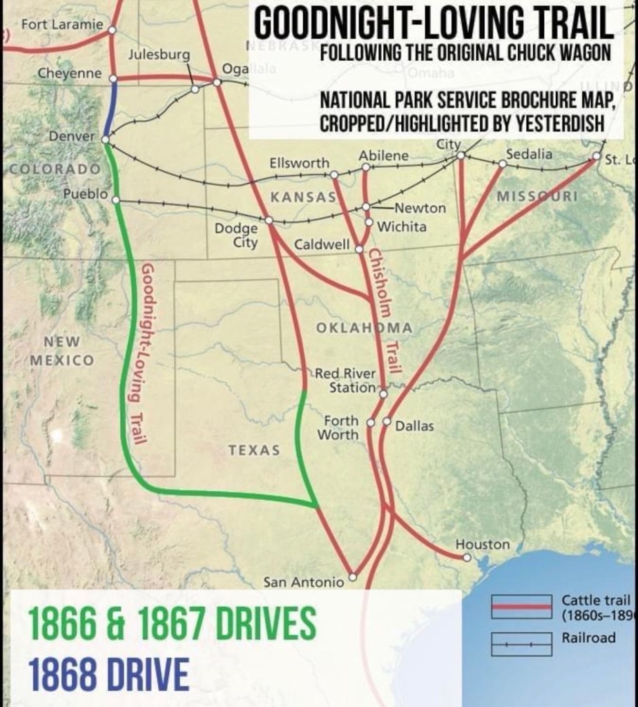
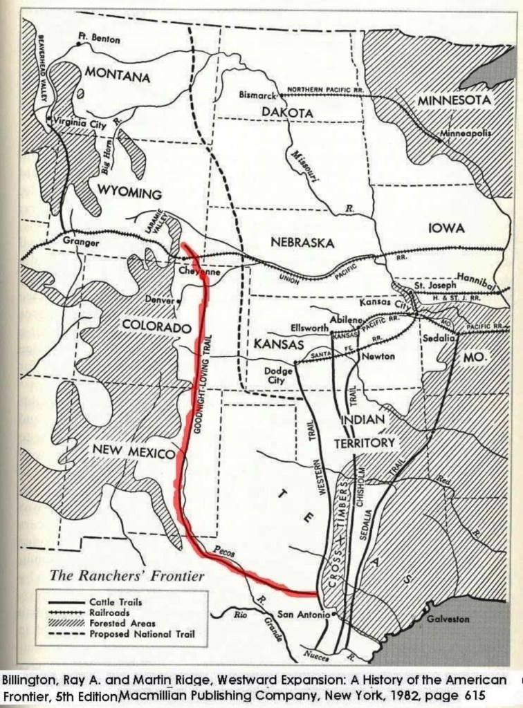
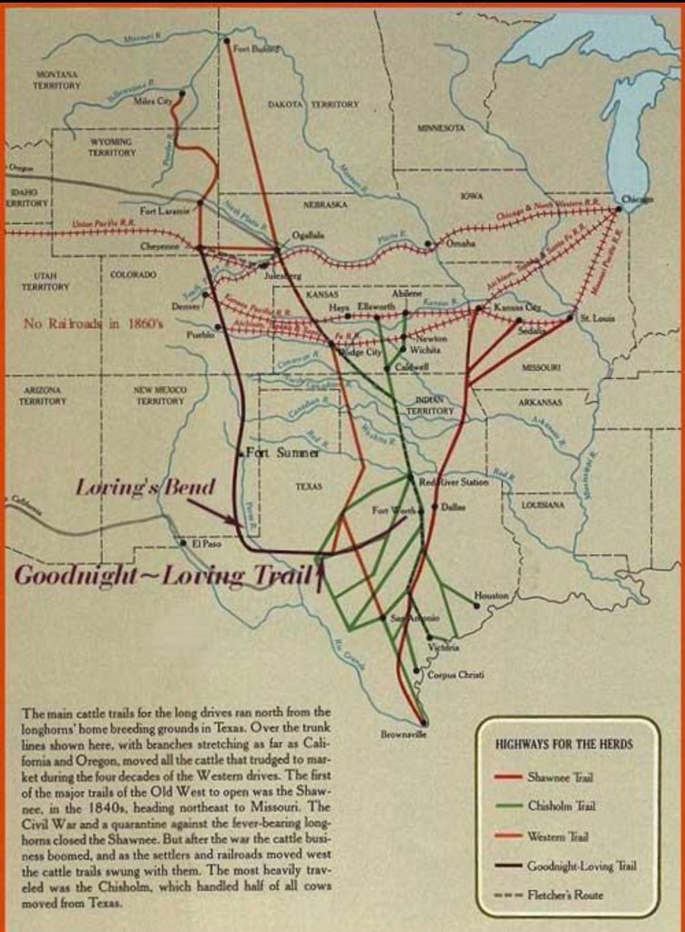
I had often wondered why the Goodnight – Loving Cattle Drive took the route it did. There seems to have been several reasons, all well thought out.
The Song:
https://suno.com/s/fTPiWFeviKllqj6f
/////////////////////////////////////////////
Alright—let’s walk it like a trail boss would, from Texas up to Colorado, the way Charles Goodnight and Oliver Loving actually laid it out.
⸻
🐂 The Goodnight–Loving Trail (Step-by-Step)
- Starting point — North Central Texas
- Begins near Fort Belknap in Young County
- Herds gathered from the Concho / Central Texas country
👉 This tied into old military/mail roads (Butterfield route)
⸻
- Southwest across West Texas
- Traveled through:
- Middle Concho River country
- Castle Gap (natural pass through rough country)
👉 This leg angled southwest, not north, to avoid the worst of the plains and reach water
⸻
- Key choke point — Pecos River crossing
- Reached Horsehead Crossing (also called Dead Horse Crossing)
- Then often used Pope’s Crossing further north
👉 This was critical: once you hit the Pecos, the route changed from “trail finding” to “follow the river”
⸻
- Turn north — up the Pecos River
- Followed the Pecos River valley north
- Crossed it multiple times depending on:
- Grass
- banks
- water access
👉 This stretch is the backbone of the whole trail
⸻
- First major destination — New Mexico
- Arrived at Fort Sumner
Why here:
- U.S. Army contracts
- Bosque Redondo reservation needed beef
👉 This was the first money stop
⸻
- From Fort Sumner — two northern options
Early route (1866)
- Up Pecos toward Las Vegas, NM
- Joined the Santa Fe Trail
- Through:
- Trinidad, Colorado
- Pueblo
- Then on to Denver
Improved route (1867+)
- Cut northeast across:
- Gallinas Valley
- Near Capulin Mountain
- Then:
- Raton Pass
- Into Colorado plains
👉 Goodnight kept straightening and improving the trail over time
⸻
- Final markets — Colorado (and beyond)
- Major endpoint: Denver
- Later extended to:
- Pueblo
- Cheyenne, Wyoming (railhead)
👉 This is where cattle hit railroads and mining markets
⸻
📍 Simple “Trail Boss Map” (Mental Picture)
Think of it like a big sideways “L”:
- Texas (Fort Belknap)
↓ southwest - Across West Texas
↓ - Pecos River (Horsehead Crossing)
↑ north (long stretch) - Fort Sumner, NM
↗ northwest / north - Raton Pass → Colorado
↑ - Denver / Cheyenne
⸻
🧭 Why it looks crooked (but isn’t)
- Southwest leg = get to water (Pecos)
- Long north leg = follow survival route
- Northern bend = reach railroads & markets
👉 It’s not wandering—it’s engineered for survival, profit, and terrain.